
Dubai Metro Map (2026)
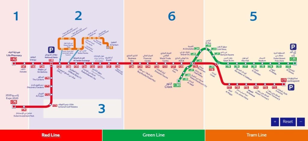
The Dubai Metro is a two-line, fully automated network spanning roughly 90 km. The Red Line runs about 52 km with 35 stations from the airport across the city to Expo; the Green Line loops 23 km through Deira and old Bur Dubai with 20 stations. The two meet at Union and BurJuman. The interactive map below is colour-coded by fare zone — tap any station to open its page.
Interactive Network Map
Zone 5
Zone 6
Zone 2
Zone 1 / Route 2020
Interchange
Red Line — 35 stations (R11 → R76)
More about the Red LineCentrepointR11EmiratesR12Airport Terminal 3R13Airport Terminal 1R14Al GarhoudR15City Centre DeiraR16Al RiggaR17UnionR18BurJumanR19ADCBR20MaxR21World Trade CentreR22Emirates TowersR23Financial CentreR24Burj Khalifa/Dubai MallR25Business BayR26ONPASSIVER29EquitiR31Mall of the EmiratesR32InsuranceMarketR33Dubai Internet CityR34Al Fardan ExchangeR35Sobha RealtyR36DMCCR37National PaintsR38Ibn BattutaR39EnergyR40DanubeR41Life PharmacyR42The GardensR70Discovery GardensR71Al FurjanR72Jumeirah Golf EstatesR73Dubai Investment ParkR74Expo 2020R76
Green Line — 20 stations (G11 → G30)
More about the Green LineEtisalat by e&G11Al QusaisG12Dubai Airport Free ZoneG13Al NahdaG14StadiumG15Al QiyadahG16Abu HailG17Abu Baker Al SiddiqueG18Salah Al DinG19UnionG20Baniyas SquareG21Gold SouqG22Al RasG23Al GhubaibaG24Sharaf DGG25BurJumanG26Oud MethaG27Dubai Healthcare CityG28Al JadafG29CreekG30
🔵 The Blue Line (14 stations, opening target 2029) is under construction and not shown as operational here. See the Blue Line page.
The Lines at a Glance
🔴 Red Line
- ~52 km · 35 stations
- Centrepoint → Expo 2020, with a Route 2020 branch
- Airport, Downtown, DIFC & the Marina
- Red Line guide →
🟢 Green Line
- ~23 km · 20 stations
- Etisalat → Creek
- Deira, the souks & historic Bur Dubai
- Green Line guide →
How to Navigate Using the Map
🗺️ Plan your journey
- Find your start and end stations
- Check which line(s) you need
- See if you transfer at Union or BurJuman
- Count the zones to estimate the fare
- Check operating hours and frequency
🔄 Transfer stations
- Union — main Red ↔ Green interchange in Deira
- BurJuman — second interchange, near Bur Dubai
- Short, signed walkways between platforms (English & Arabic)
RTA Dubai app
The official app shows live metro times, service status and fares, and plans journeys across the whole network — the single most useful tool to have on your phone in Dubai.
Maps integration
Everyday map apps include the Dubai Metro, so you can search a destination and get full door-to-door directions that combine walking with the right metro line and station.
Station displays
Every platform has screens counting down to the next train and showing its destination, plus clear line maps and signage in English and Arabic so you always know where to stand.
Station QR codes
Scan the QR codes posted around stations to pull up live information, station maps and service updates on your phone without needing to download anything first.
Future Expansion
The next major addition is the Blue Line — around 30 km and 14 stations, under construction with a 2029 target. It will connect fast-growing eastern communities such as Dubai Creek Harbour, Silicon Oasis and Academic City, and add new interchanges to the network.
Frequently Asked Questions
How many lines does the Dubai Metro have?
Two operational lines — the Red Line (35 stations) and the Green Line (20 stations) — with a third, the Blue Line, under construction.
How do I transfer between the Red and Green lines?
Change at Union or BurJuman; both let you switch lines without leaving the paid area, with signage in English and Arabic.
Can I use the same Nol card for metro and bus?
Yes. The same Nol card works on the metro, tram, buses and water transport, and linked transfers count as one journey.
Is the Dubai Metro wheelchair accessible?
Yes — every station has lifts and step-free access, and all trains have dedicated wheelchair spaces.
What is the fastest route to The Dubai Mall?
Take the Red Line to Burj Khalifa/Dubai Mall, then the air-conditioned link bridge straight into the mall.
When will the Blue Line open?
The official opening target is 9 September 2029.